Stereo Visual Inertial LiDAR Simultaneous Localization and Mapping
Abstract
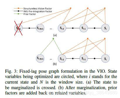
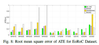
Simultaneous Localization and Mapping (SLAM) is a fundamental task to mobile and aerial robotics. LiDAR based systems have proven to be superior compared to vision based systems due to its accuracy and robustness. In spite of its superiority, pure LiDAR based systems fail in certain degenerate cases like traveling through a tunnel. We propose Stereo Visual Inertial LiDAR (VIL) SLAM that performs better on these degenerate cases and has comparable performance on all other cases. VIL-SLAM accomplishes this by incorporating tightly-coupled stereo visual inertial odometry (VIO) with LiDAR mapping and LiDAR enhanced visual loop closure. The system generates loop-closure corrected 6-DOF LiDAR poses in real-time and 1cm voxel dense maps near real-time. VIL-SLAM demonstrates improved accuracy and robustness compared to state-of-the-art LiDAR methods. 摘要:同时定位和地图绘制(SLAM)是移动和空中机器人技术的一项基本任务。 与基于视觉的系统相比,基于LiDAR的系统在准确性和鲁棒性已被证明是更优的。尽管基于雷达系统更优,但是基于纯LiDAR的系统在某些退化的情况下仍无法正常工作,例如穿越隧道。我们提出了立体视觉惯性激光雷达(VIL)SLAM,在这些退化情况下性能更好,并且在所有其他情况下具有良好的性能。 VIL-SLAM通过将紧耦合的立体视觉惯性里程计(VIO)与LiDAR建图和LiDAR增强的视觉环路闭合功能结合在一起,实现了这一目标。该系统实时生成闭环校正的6自由度LiDAR姿态,并实时生成1cm体素密集图。与最优的LiDAR方法相比,VIL-SLAM展示出更高的准确性和鲁棒性。
A GPS-aided Omnidirectional Visual-Inertial State Estimator in Ubiquitous Environments
Abstract
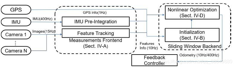
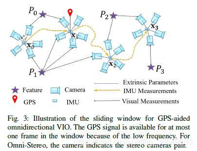
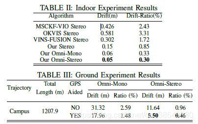
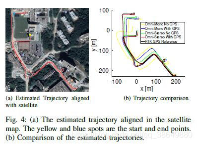
The visual-inertial navigation system (VINS) has been a practical approach for state estimation in recent years. In this paper, we propose a general GPS-aided omnidirectional visual-inertial state estimator capable of operating in ubiquitous environments and platforms. Our system consists of two parts: 1) the pre-processing of omnidirectional cameras, IMU, and GPS measurements, and 2) the sliding window based nonlinear optimization for accurate state estimation. We test our system in different conditions including an indoor office, campus roads, and challenging open water surface. Experiment results demonstrate the high accuracy of our approach than state-of-the-art VINSs in all scenarios. The proposed odometry achieves drift ratio less than 0.5% in 1200 m length outdoors campus road in overexposure conditions and 0.65% in open water surface, without a loop closure, compared with a centimeter accuracy GPS reference. 摘要:视觉惯性导航系统(visual-inertial navigation system,VINS)是近年来发展起来的一种实用的状态估计方法。在这篇论文中,我们提出了一种通用的GPS辅助全向视觉惯性状态估计器,它能够在各种环境和平台上工作。该系统由两部分组成:1)全向相机、IMU和GPS量测的预处理;2)基于滑动窗口的非线性优化精确状态估计。我们在不同的条件测试了该系统,包括室内办公室,校园道路和具有挑战性的开阔水面。实验结果表明,在所有情况下,我们方法的精度高于最先进的VINSs。所提出的里程计在1200米长的室外校园道路中,在过曝条件下的漂移率小于0.5%,在开放水面上的漂移率为0.65%,在没有环路闭合的情况下,与厘米精度的GPS基准相当。