关注微信公众号“混沌无形”,后台回复:13462F2。免费获取完整工程源码!

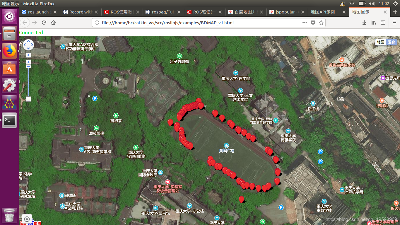
基于USB-RS232协议输出UM220-III/3-N/北斗GPS模块定位信息,使用ROS与js的接口包——roslibjs,调用百度地图js API,并可视化数据,笔者测试的效果如下(红点表示经过的路径点,GPS/北斗数据存在误差,所以路径点不连续)
使用者需要先下载安装roslibjs,再注册百度地图或高德地图。
读取GPS/北斗的定位数据代码
import serial

import rospy

from nmea_msgs.msg import Sentence
from libnmea_navsat_driver.driver import RosNMEADriver

if __name__ == '__main__':
    rospy.init_node('nmea_topic_serial_reader')

    # fine when using 10 Hz
    nmea_pub = rospy.Publisher("nmea_sentence", Sentence, queue_size=3)

    serial_port = rospy.get_param('~port','/dev/ttyUSB0')
    serial_baud = rospy.get_param('~baud',115200)

    # Get the frame_id
    frame_id = RosNMEADriver.get_frame_id()

    try:
        GPS = serial.Serial(port=serial_port, baudrate=serial_baud, timeout=2)
        while not rospy.is_shutdown():
            data = GPS.readline().strip()

            sentence = Sentence()
            sentence.header.stamp = rospy.get_rostime()
	    sentence.header.frame_id = frame_id
            sentence.sentence = data

            nmea_pub.publish(sentence)

    except rospy.ROSInterruptException:
        GPS.close() #Close GPS serial port
数据点在网页的可视化代码为
<!DOCTYPE html>
<html>
<head>
<meta http-equiv="Content-Type" content="text/html; charset=utf-8" />
<meta name="viewport" content="initial-scale=1.0, user-scalable=no" />
<style type="text/css">
		body, html,#allmap {width: 100%;height: 100%;overflow: hidden;margin:0;font-family:"微软雅黑";}
	</style>
<title>地图显示</title>
<script  src="http://api.map.baidu.com/api?v=2.0&ak=Ii2oy8BEXRtwXOW1wo0oRb4xGneV6nCm"></script>

<script src="https://static.robotwebtools.org/EventEmitter2/current/eventemitter2.min.js"></script>
<script src="../build/roslib.js"></script>
</head>

<body>

  <div id="statusIndicator">
    <p id="connecting">
      Connecting to rosbridge...
    </p>
    <p id="connected" style="color:#00D600; display:none">
      Connected
    </p>
    <p id="error" style="color:#FF0000; display:none">
      Error in the backend!
    </p>
    <p id="closed" style="display:none">
      Connection closed.
    </p>
  </div>
</ol>
  <div id="allmap"></div>

<script type="text/javascript">
  // Connecting to ROS
  // -----------------
  var ros = new ROSLIB.Ros();

  // If there is an error on the backend, an 'error' emit will be emitted.
  ros.on('error', function(error) {
    document.getElementById('connecting').style.display = 'none';
    document.getElementById('connected').style.display = 'none';
    document.getElementById('closed').style.display = 'none';
    document.getElementById('error').style.display = 'inline';
    console.log(error);
  });

  // Find out exactly when we made a connection.
  ros.on('connection', function() {
    console.log('Connection made!');
    document.getElementById('connecting').style.display = 'none';
    document.getElementById('error').style.display = 'none';
    document.getElementById('closed').style.display = 'none';
    document.getElementById('connected').style.display = 'inline';
  });

  ros.on('close', function() {
    console.log('Connection closed.');
    document.getElementById('connecting').style.display = 'none';
    document.getElementById('connected').style.display = 'none';
    document.getElementById('closed').style.display = 'inline';
  });

  // Create a connection to the rosbridge WebSocket server.
  ros.connect('ws://localhost:9090');

  // define two global variant
  var x = 0;
  var y = 0;

  //Subscribing to a Topic
  //----------------------

  // Like when publishing a topic, we first create a Topic object with details of the topic's name
  // and message type. Note that we can call publish or subscribe on the same topic object.
  var carPose = new ROSLIB.Topic({
    ros : ros,
    name : '/simplegps',
    messageType : 'geometry_msgs/Pose2D'
  });

  var sample = new ROSLIB.Topic({
    ros : ros,
    name : '/simplegps',
    messageType : 'geometry_msgs/Pose2D'
  });
  // Then we add a callback to be called every time a message is published on this topic.

  carPose.subscribe(function (message) {
    window.x = message.x;
    window.y = message.y;
    var map = new BMap.Map("allmap",{minZoom:3,maxZoom:19}); // 创建Map实例,设置地图允许的最小/大级别

    var gpspoint = new BMap.Point(window.x, window.y); // 创建点坐标

    // 添加带有定位的导航控件
  var navigationControl = new BMap.NavigationControl({
    // 靠左上角位置
    anchor: BMAP_ANCHOR_TOP_LEFT,
    // LARGE类型
    type: BMAP_NAVIGATION_CONTROL_LARGE,
    // 启用显示定位
    enableGeolocation: true
  });
  map.addControl(navigationControl);


// 添加定位控件
  var geolocationControl = new BMap.GeolocationControl();
  geolocationControl.addEventListener("locationSuccess", function(e){
    // 定位成功事件
    var address = '';
    address += e.addressComponent.province;
    address += e.addressComponent.city;
    address += e.addressComponent.district;
    address += e.addressComponent.street;
    address += e.addressComponent.streetNumber;
    alert("当前定位地址为:" + address);
  });
  geolocationControl.addEventListener("locationError",function(e){
    // 定位失败事件
    alert(e.message);
  });
  map.addControl(geolocationControl);


    //添加地图类型控件
	map.addControl(new BMap.MapTypeControl({
		mapTypes:[
            BMAP_NORMAL_MAP,
            BMAP_HYBRID_MAP
        ]}));
    map.setCurrentCity("重庆");          // 设置地图显示的城市 此项是必须设置的

  //坐标转换完之后的回调函数
    translateCallback = function (data){

	var bdpoint = data.points[0];
     	map.centerAndZoom(bdpoint, 12);

    	map.enableScrollWheelZoom(true);     //开启鼠标滚轮缩放
	function Sample()  //标住更新的位置
	{
 		sample.subscribe(function (message) {
    		window.x = message.x;  //更新点坐标
    		window.y = message.y;
		var gpspoint = new BMap.Point(window.x, window.y); // 创建点坐标
   		translateCallback1 = function (data)
			{
			var bdpoint1 = data.points[0]	//创建点坐标
			var marker = new BMap.Marker(bdpoint1); // 创建标注
       			map.addOverlay(marker); // 将标注添加到地图中
        		}

		function zbzh1()   //坐标转换
		{
 			var convertor = new BMap.Convertor();
       			var pointArr = [];
       			pointArr.push(gpspoint);
        		convertor.translate(pointArr, 1, 5, translateCallback1)
		}

		zbzh1();
		sample.unsubscribe();
  		});
	}

  	function xh() //无限循环
	{


			setTimeout(function(){
			Sample ();
			xh();
					},3000);


	}

   	setTimeout(xh(),3000);
    }


    function zbzh()   //坐标转换
	{
 	var convertor = new BMap.Convertor();
        var pointArr = [];
        pointArr.push(gpspoint);
        convertor.translate(pointArr, 1, 5, translateCallback)
	}

    zbzh();

    // If desired, we can unsubscribe from the topic as well.
    carPose.unsubscribe();
  });

</script>

</body>
</html>
喜欢的话,请关注微信公众号,可阅读更多好文!
本文内容由网友自发贡献,版权归原作者所有,本站不承担相应法律责任。如您发现有涉嫌抄袭侵权的内容,请联系:hwhale#tublm.com(使用前将#替换为@)