1.参考
GeoServer发布Heatmap - wenglabs - 博客园
Rendering Transformations — GeoServer 2.21.x User Manual
2.下载 GeoServer 及wps插件,该插件gs:heatmap支持热图样式
3.发布测试shp
geoserver热图测试数据-其它文档类资源-CSDN下载
4、添加热图样式,刚才发布的图层设置该样式,注意里面的权重字段
weightAttr为权重字段[0,1]
<?xml version="1.0" encoding="ISO-8859-1"?>
<StyledLayerDescriptor version="1.0.0"
           xsi:schemaLocation="http://www.opengis.net/sld StyledLayerDescriptor.xsd"
    xmlns="http://www.opengis.net/sld"
    xmlns:ogc="http://www.opengis.net/ogc"
    xmlns:xlink="http://www.w3.org/1999/xlink"
    xmlns:xsi="http://www.w3.org/2001/XMLSchema-instance">
    <NamedLayer>
        <Name>Heatmap</Name>
        <UserStyle>
            <Title>Heatmap</Title>
            <Abstract>A heatmap surface showing population density</Abstract>
            <FeatureTypeStyle>
                <Transformation>
                    <ogc:Function name="gs:Heatmap">
                        <ogc:Function name="parameter">
                            <ogc:Literal>data</ogc:Literal>
                        </ogc:Function>
                        <ogc:Function name="parameter">
                            <ogc:Literal>weightAttr</ogc:Literal>
                            <ogc:Literal>maxwater</ogc:Literal>
                        </ogc:Function>
                        <ogc:Function name="parameter">
                            <ogc:Literal>radiusPixels</ogc:Literal>
                            <ogc:Function name="env">
                                <ogc:Literal>radius</ogc:Literal>
                                <ogc:Literal>100</ogc:Literal>
                            </ogc:Function>
                        </ogc:Function>
                        <ogc:Function name="parameter">
                            <ogc:Literal>pixelsPerCell</ogc:Literal>
                            <ogc:Literal>10</ogc:Literal>
                        </ogc:Function>
                        <ogc:Function name="parameter">
                            <ogc:Literal>outputBBOX</ogc:Literal>
                            <ogc:Function name="env">
                                <ogc:Literal>wms_bbox</ogc:Literal>
                            </ogc:Function>
                        </ogc:Function>
                        <ogc:Function name="parameter">
                            <ogc:Literal>outputWidth</ogc:Literal>
                            <ogc:Function name="env">
                                <ogc:Literal>wms_width</ogc:Literal>
                            </ogc:Function>
                        </ogc:Function>
                        <ogc:Function name="parameter">
                            <ogc:Literal>outputHeight</ogc:Literal>
                            <ogc:Function name="env">
                                <ogc:Literal>wms_height</ogc:Literal>
                            </ogc:Function>
                        </ogc:Function>
                    </ogc:Function>
                </Transformation>
                <Rule>
                    <RasterSymbolizer>
                        <!-- specify geometry attribute to pass validation -->
                        <Geometry>
                            <ogc:PropertyName>geom</ogc:PropertyName>
                        </Geometry>
                        <Opacity>0.6</Opacity>
                        <ColorMap type="ramp" >
                            <ColorMapEntry color="#0000FF" quantity="0" label="nodata" opacity="0"/>
                            <ColorMapEntry color="#00FFFF" quantity="0.02" label="nodata" opacity="0"/>
                            <ColorMapEntry color="#00FF00" quantity=".1" label="nodata"/>
                            <ColorMapEntry color="#FFFF00" quantity=".5" label="values" />
                            <ColorMapEntry color="#FF0000" quantity="1" label="values" />
                        </ColorMap>
                    </RasterSymbolizer>
                </Rule>
            </FeatureTypeStyle>
        </UserStyle>
    </NamedLayer>
</StyledLayerDescriptor>
5.前端demo
<!doctype html>
<html lang="en">
	<head>
		<meta http-equiv="Content-Type" content="text/html; charset=utf-8" />
		<title>热图</title>
		<link rel="stylesheet"
			href="https://cdn.jsdelivr.net/gh/openlayers/openlayers.github.io@master/en/v6.9.0/css/ol.css"
			type="text/css">
		<style>
			html,
			body,
			.map {
				height: 100%;
				width: 100%;
				margin: 0;
				padding: 0
			}
		</style>
	</head>
	<body>
		<div id="map" class="map"></div>
	</body>
	<script src="https://cdn.jsdelivr.net/gh/openlayers/openlayers.github.io@master/en/v6.9.0/build/ol.js"></script>
	<script>
		var gaodeMapLayer = new ol.layer.Tile({
			source: new ol.source.XYZ({
				url: 'http://t0.tianditu.com/vec_w/wmts?service=wmts&request=GetTile&version=1.0.0&LAYER=vec&tileMatrixSet=w&TileMatrix={z}&TileRow={y}&TileCol={x}&style=default&format=tiles&tk=40b190683706230fade806c1ac8c14e8'
				// url: 'http://wprd0{1-4}.is.autonavi.com/appmaptile?lang=zh_cn&size=1&scl=2&style=7&x={x}&y={y}&z={z}'
			}),
			visible: true
		});

		/**
		 * 创建地图对象并添加图层
		 */
		var map = new ol.Map({
			target: 'map',
			controls: ol.control.defaults({
				zoom: false
			}),
			layers: [gaodeMapLayer],
			view: new ol.View({
				center: transform([108.948301, 34.223445]),
				// center: [108.948301, 34.223445],
				// projection: 'EPSG:4326',
				zoom: 14.5,
			})
		});

		function transform(pois) {
			return ol.proj.transform(pois, 'EPSG:4326', 'EPSG:3857')
		}

		var base_url = 'http://localhost:8080/geoserver';
		new ol.layer.Image({
			source: new ol.source.ImageWMS({
				url: base_url + "/test/wms",
				params: {
					VERSION: '1.1.1',
					LAYERS: 'manhole_deep_P1',
					FORMAT: 'image/png',
				}
			}),
			map: map
		});

		// 瓦片有点问题
		new ol.layer.Tile({
			source: new ol.source.TileWMS({
				url: base_url + "/test/wms",
				params: {
					VERSION: '1.1.1',
					LAYERS: 'manhole_deep_P1',
					FORMAT: 'image/png',
					TILED: true
				}
			}),
			// map: map
		})

		// 瓦片有点问题
		new ol.layer.Tile({
			source: new ol.source.XYZ({
				url: base_url + '/gwc/service/wmts?' +
					'layer=test:manhole_deep_P1&style=&tilematrixset=EPSG:900913&' +
					'Service=WMTS&Request=GetTile&Version=1.0.0&Format=image/png&' +
					'TileMatrix=EPSG:900913:{z}&TileCol={x}&TileRow={y}'
			}),
			visible: true,
			// map: map
		});
	</script>
</html>
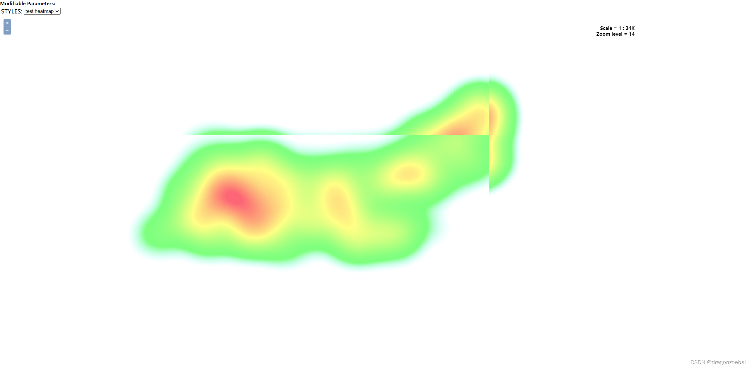
6、最后效果
wms正常

瓦片却不正常,哪位同学指教下。
本文内容由网友自发贡献,版权归原作者所有,本站不承担相应法律责任。如您发现有涉嫌抄袭侵权的内容,请联系:hwhale#tublm.com(使用前将#替换为@)